One of my high school teachers once imparted this piece of wisdom: "It's better to be approximately right than completely wrong." He was an unlikely source of such advice as he taught math, one of the disciplines where there usually is a very clear distinction between right and wrong. Then again, math is also the discipline of getting as close as possible to approximating natural systems and phenomena. And that's where it's far better to be approximately right than to be totally wrong.
Take GPS for example (I use "GPS" in this article to refer to positioning, even though GPS really only refers to the US version of global navigation satellite systems). It's become part of life. We no longer have to ask for directions. We just type or speak an address and our phone or car will know where to go, no matter how far it is. But how precise is the positioning in phones and cars? Not very. As long as the system knows what road we're on, that's good enough. No need for accuracy within feet. To be approximately right is good enough.
How approximately right do you need to be?
But what is the definition of approximately right and good enough? The answer is, as it is so often, "it depends." In positioning there is no absolute accuracy. This is about satellites in space sending signals that are received down on the surface of the earth. Knowing how long it takes the signals from three or four satellites to reach the receiver is enough to triangulate its position. 
Theoretically these computations yield the exact, precise spot, but few things in nature are ever precise. Signals may be bounced off or reflected. The weather may be bad. There may be trees or buildings in the way. All of those things can affect positioning accuracy, to the extent where "approximately right" is no longer good enough.
There are various ways to improve positioning accuracy.
Examples are DGPS (Differential GPS) where a fixed, known position is used to correct GPS signals; AGPS (Assisted GPS), where assistance from local cell towers enhances the satellite data; RTK (Real Time Kinematic), where fixed base stations send out corrections to a moving receiver; SBAS (Satellite Based Augmentation System), that provides validated, corrected information to the receiver; or NTRIP (Network Transport of RTCM via Internet Protocol) that provides various correction methods from a network of known receivers.
There are other approaches as well, including post-processing where recorded positioning data is enhanced by various means.
If all that sounds complicated, it is. In essence, GPS has gone in two different directions.
One is the ubiquitous "GPS" that's become part of our life. It's simply there. No need to know anything other than following the map.
The other is the increasingly sophisticated technology enabling ever more precise positioning systems. That world has its own nomenclature, terminologies, abbreviations, standards and, of course, bevy of competing, complementary, and often proprietary systems.
Ever more precise positioning systems
 The good news about the latter is that there's ever improving positioning accuracy. The not so good news is that it comes at a cost.
The cost that, unlike the inexpensively scalable processing power of computers, includes additional technologies, additional software and algorithms, and at times additional service charges.
What that means is that there is a direct correlation between additional accuracy and higher cost, and that correlation is on an asymptotic curve, i.e. a curve that gets steeper the closer it gets to an absolute line, that being absolute accuracy, which is never possible.
Confused yet? There's no need. All it means is that in GPS there's a rapidly increasing cost to increasing degrees of being approximately right. So let's look at current standards of GPS "accuracy."
What does accuracy mean in the first place? For GPS systems it's the radius of the circle around the receiver.
A current cell phone or consumer tablet generally yields about 5-7 meter accuracy, i.e. most readings are within a 10-14 meter diameter circle.
High-end tablets for vertical market deployments have 2-4 meter accuracy, and that's about as good as it generally gets with integrated positioning. That's actually quite good and more than suitable for most mapping projects. Most, but not all.
Increasing demand for accuracy
As the use of rugged mobile handhelds, tablets and laptops becomes ever more widespread, so does the range of applications that require accuracy better than just knowing what road one might be on. 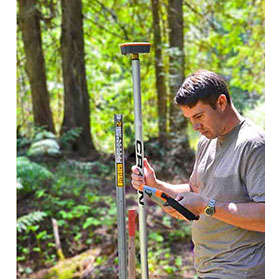 So there's an increasing demand for systems that can do better than what standard COTS technology can provide, but that should cost less than the steep price of dedicated survey grade equipment. What does "survey grade" accuracy mean? For now, the border between "mapping grade" and "survey grade" accuracy is at the 1-foot level.
How much does accuracy cost? That's continuously changing as technology advances. And it once again depends on how "approximately right" one wants/needs to be.
For now, an interesting range of positioning accuracy is better than even high end handhelds and tablets can do, but without being fully survey grade. That's where "sub-meter" receivers come in. Sub-meter means that most results should come in within 3.3 feet of the received location in any direction.
By and large, this type of accuracy might cost in the US$2,500 range. Too much to be a standard add-on to even a good tablet or handheld, but a bargain compared to dedicated survey gear.
Genesis of Geode
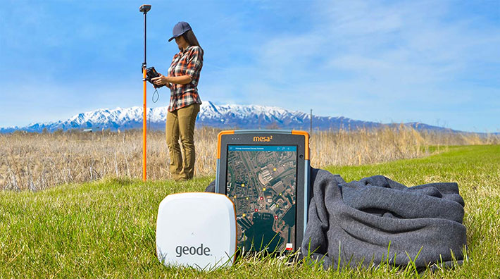
And that's where we finally, finally get to Juniper System's Geode itself. Juniper has been providing rugged handhelds and small tablets for special markets for many years, and those markets increasingly demand high positioning accuracy. Offering such products would increase Juniper's potential markets and it would certainly please existing customers, but not if it came with a significant increase in device price.
 So the Juniper folks sat down, considered their core values (reliable, durable, portable, compatible), looked at how they usually test their stuff (I won't go into details, but it involves egregious abuse), and then looked up and said, "Hey, why don't we make a super-receiver that's as tough as a hockey puck?" So they started Project Gretzky, so named because Wayne Gretzky was super and he loved hockey pucks.
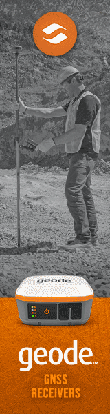
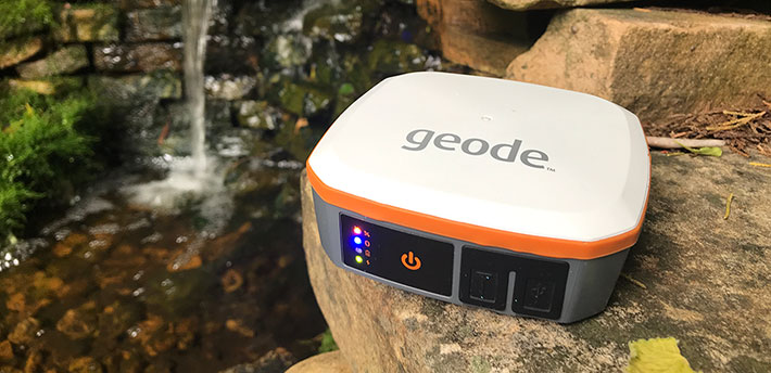
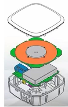
The result is the Juniper Geode Sub-meter GPS Receiver. It does look just like a hockey puck, but with the exception that it's white, sort of square with rounded corners, and weighs twice as much.
And, unlike a hockey puck, it can be mounted almost anywhere via different mounting standard screw holes, it has a long-lasting 19.35 watt-hour battery, a professional-grade Hemisphere Crescent P206 receiver board, and Tallysman TW2710 high-sensitivity dual-feed antenna, all packed into an IP68-sealed housing.
The finished Project Gretzky also doesn't connect to hockey sticks, but instead to handhelds and tablets via long-range (up to 100 feet) Bluetooth or USB, or, optionally, via RS232C serial.
It has four indicator lights. Green for power on, blinking or solid red for charging or fully charged, blue for Bluetooth connection, and blinking or solid amber for GPS and DGPS fix.
Its micro-USB port is mostly for charging via the included adapter, the MCX antenna connector is primarily to get good signal when the Geode itself is obscured, and the optional serial port can be used with a straight-through cable for communication and, as an extra, directly upload firmware upgrades when they are available.
How does the Geode work?
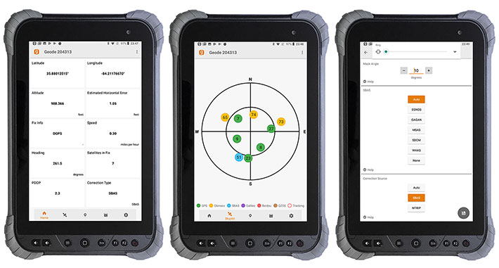
How does the Geode work? That, again, depends. Connecting via Bluetooth is as straightforward as Bluetooth generally is. A (free) Geode Connect Utility is available for Windows 8 or 10, Windows Mobile, and Android. Depending on the platform, Geode Connect allows setting of preferences (units, formats, environments, waypoints, tracks, file types, and some more advanced settings) and shows positioning data.
The pictures below show some of the Geode Connect screens, displayed on the 8-inch display of Juniper Sytem's recently (early 2019) introduced Cedar CT8 rugged Android tablet. On the left is the Geode Connect status screen that provides a dashboard view of real time data. In the middle is a graphic representation of the satellites the Geode has locked on to. Our version supported both GPS (green) and GLONASS (yellow) satellites. The SBAS satellite is shown in blue. On the right is one of the Geode Collect configuration screens. This one allows setting the mask angle for satellites, as well as correction source type and SBAS handling method.
Note that although all of Juniper Systems' new hardware is either Windows 10 or Android, all of its legacy products ran Windows Mobile, and some of the features in the Windows Mobile version of Geode Connect are not available (yet) in the Android version. Likewise, the question has come up whether there will be a Geode Connect version for IOS. Juniper indicated there would be, but we haven't seen it as of yet.
Geode capabilities
Now lets get to the "it depends" part of putting the Geode's considerable capabilities to work. If you thought it'd be cool to get a Geode to instantly have much better accuracy for whatever app uses GPS in your device, that's not the way it works. An app must be able to connect to an external Bluetooth GPS receiver. Not every app does. And of those that do, the Geode works best with specific optimized apps.
That's currently a number of special purpose mapping and mapping support apps such as, depending on the platform, ArcPad, Juniper Aspect, Survey123 for ArcGIS, ESRI Collector for ArcGIS, Carlson SurvCE, Terrago, Effigis OnPOZ and Effigis EZSurv, Mapit GIS, SW Maps and more. The number of apps that support external GNSS receivers is growing (see 13 GIS data collection apps professionals should try) but, for now, don't expect sudden super-accuracy in Google Maps or (the now weirdly cartoonish) Google Earth. There is also the oddly named "mock location provider" function in Android that can provide external receiver GPS data to apps.
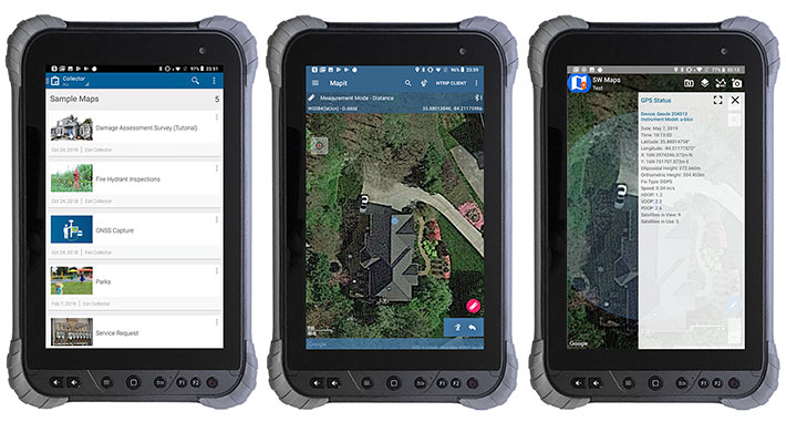
Below are screen snaps of some Geode-compatible mapping apps, from left to right Collector for ArcGIS, mapitGIS, and SW Maps.
Why is that? Why can't the Geode just deliver superior accuracy to all apps that need it? That's because communication between GPS receivers and the app that use the GPS data is highly standardized. The receiver and the app must agree what data and commands are to be used, and that's all regulated via NMEA 0183, a National Marine Electronics Association standard that covers communication between all sorts of marine electronics and also GPS receivers. Most of that data isn't needed for simple navigation, and so consumer mapping apps don't support it.
That's primarily because consumer devices, running Android or iOS, were designed to work with the low-level consumer-grade accuracy received built into smartphones and tablets. Those operating systems were never designed "out of the box" to deal with high-accuracy data, so methods like "Mock Locations" have to be employed to deliver higher accuracy data to the operating system.
What can one expect from the Geode. Once again, it depends. It depends on the app it's used with, it depends on proper settings, it depends on proper use, and proper resources. In other words, this is a tool for professionals. Juniper published some very impressive YouTube videos demonstrating the accuracy of the Geode. Results consistently were well within the 1-meter circle, often within the 1-foot radius, and once run through suitable postprocessing software, within a 2-inch radius. Impressive indeed.
How much does the Geode cost?
How much does the Geode cost? That depends on the model. Those include versions that support just GPS or also GLONASS, Galileo and Beidou (more satellites means more reliable and more consistent data), and versions with or without the serial port. Multi-GNSS is available as an upgrade, and customers can also get 2, 5, and 10 HZ update rates instead of the default once per second. Price range for those models is from about US$1,400 to US$2,000. That's well below the roughly $2,500 that's been the going price for sub-meter performance.
How did the Geode do in our testing?
How well did the Geode work in RuggedPCReview's testing? After we figured out some of the basic rules (like Geode Connect can't be on if you want to connect to an app, unless Geode Connect is used as a mock location provider for that app), accuracy indeed was way beyond what we usually see from devices with integrated GPS. So far beyond that anyone who's used a Geode will have a hard time to go back to the much looser "approximately right" standards of most handhelds and tablets.
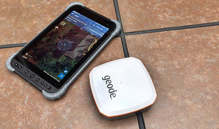
Using Mapit GIS and focussing in on our office, the blue dot unerringly sat right next to the window where we had placed the Geode. Placing the Geode on specific spots on the property always had the blue dot within three feet at most, and usually better. Impressive to say the least.
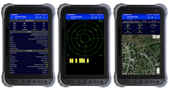
Testing with Ultra GPS Logger, downloaded from the Google Play Store, also allowed connecting to the Geode via Bluetooth and yielded good results.
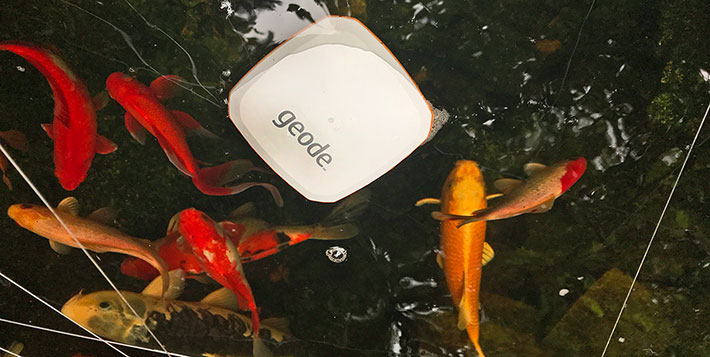
Finally, we did put Juniper's casual mention that the IP68-sealed Geode floats to the test in a nearby Koi pond. It does float, and it never missed a beat in broadcasting its precise location, even in the water. The fish were quite interested in the Geode. Once they realized it wasn't edible or dispensed food, they swam off, leaving the drifting Geode to accurately report its position in the Koi pond.
Overall, with the Geode, Juniper Systems is making sub-meter GPS accuracy available to a wide range of Windows and Android-based handhelds and tablets at a remarkably low cost. While the Geode is a Juniper Systems product and has been extensively tested with Juniper devices, it is an open system designed to also work with third party hardware and software. -- Conrad Blickenstorfer, May 2019
Relevant Information and Links:
— Juniper Systems Geode Sub-Meter GPS Receiver page
— Juniper Systems Geode Sub-Meter GPS Receiver Spec Sheet
— Geode accessories
— Geode Connect utility screens and description
Juniper Systems Headquarters
1132 West 1700 North
Logan, UT 84321
Telephone: 435-753-1881
Fax: 435-753-1896
Web: www.junipersys.com
sales at junipersys.com